- Home
- Camp Wolters
- A Model Soldier
- Camera Trip Through Camp Wolters
- Camp Wolters Longhorn
- Camp Wolters Ephemera
- Camp Wolters Guide
- Camp Wolters IRTC
- Camp Wolters Postcards
- Camp Wolters Unit Photos
- Christmas Menu
- Present Site of Camp
- Southwestern Bell Booklet
- Camp Wolters Souvenir Book
- IRTC Doughboy
- Soldier - Billy S. West
- Soldier Artist
- Soldier's Letters
- Soldier's Photos
- Fort Wolters
- United States Primary Helicopter/School
- Flight Training
- ORWAC Class 68-24
- WORWAC Class 67-5
- Training Aircraft
- Stagefields and Heliports
- Southern Airways of Texas
- USAPHS Commandants
- Battery D, 4th Missile BN 562nd Arty
- 328th U.S. Army Band
- Det. 20, 16th Weather Squadron
- Guide and Directory
- Crash Rescue Map
- Dave Rittman Photos
- Fort Wolters Photo Gallery
- Fort Wolters Ephemera
- Wolters Air Force Base
- Fort Wolters Main Gate
- Around Mineral Wells
- Texas Forts Trail
- Vietnam
- Sitemap
- Links
- About the Site
- What's New
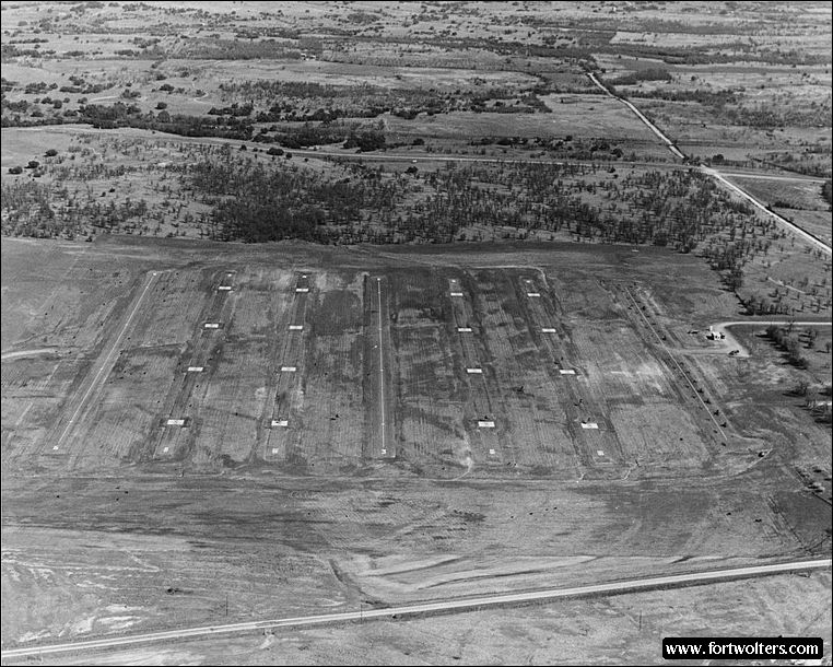
U.S. Army Photo - Boyce Ditto Library |
|
|---|---|
Stagefield: CAM RANH Latitude/Longitude:32°46'30"N97°55'23"W Army Map Service Coordinates: PM009268 Telephone Number: None Elevation: 1135 ft Traffic Pattern Altitude: 1600 ft Radio Call: Cam Ranh Frequencies: 139.10
GENERAL NOTES 2 Autorotation Lanes: 1600' x 50" each 4 Approach Lanes: 4 pads per lane - 30' x 30' No paved hovering area No fixed lighting Hand Light Gun
Windsocks: 2: 1 in NE corner, 1 in SW corner
Permanent Control Tower: Air conditioned, light gun, wind velocity and direction indicator.
Radios: 2 ARC - 60 radios (UHF) 1 ARC - 524 (VHF)
All weather access road
Distance from Fort Wolters: Air - 8 NM
Ready Room: 6 tables with chairs, no air conditioning, no water available at site, temporary latrines.
Restricted Areas: None
Remarks: Stagefield is located in Downing "Triangle"; maximum altitude outside traffice pattern is 1500' MSL.
Hazards: Unmarked powerlines on south edge of stagefield.
Traffic Pattern: Go-Around: Report go-around to control tower, climb straight ahead to 1600'. If traffic permits, tower will clear aircraft to turn crosswind and downwind at 1600' for closed traffic. If not cleared closed traffic, break traffic at 1600'; cleared to 1500' and re-enter normal traffic.
|
|