
- Home
- Camp Wolters
- A Model Soldier
- Camera Trip Through Camp Wolters
- Camp Wolters Longhorn
- Camp Wolters Ephemera
- Camp Wolters Guide
- Camp Wolters IRTC
- Camp Wolters Postcards
- Camp Wolters Unit Photos
- Christmas Menu
- Present Site of Camp
- Southwestern Bell Booklet
- Camp Wolters Souvenir Book
- IRTC Doughboy
- Soldier - Billy S. West
- Soldier Artist
- Soldier's Letters
- Soldier's Photos
- Fort Wolters
- United States Primary Helicopter/School
- Flight Training
- ORWAC Class 68-24
- WORWAC Class 67-5
- Training Aircraft
- Stagefields and Heliports
- Southern Airways of Texas
- USAPHS Commandants
- Battery D, 4th Missile BN 562nd Arty
- 328th U.S. Army Band
- Det. 20, 16th Weather Squadron
- Guide and Directory
- Crash Rescue Map
- Dave Rittman Photos
- Fort Wolters Photo Gallery
- Fort Wolters Ephemera
- Wolters Air Force Base
- Fort Wolters Main Gate
- Around Mineral Wells
- Texas Forts Trail
- Vietnam
- Sitemap
- Links
- About the Site
- What's New
| Army Airfields/Heliports | Field Elev. |
Coordinates |
Location | |
| Dempsey Heliport | 1153' |
32°46'42"N 98°16'24"W | NM681264 | |
| Downing Heliport | 964' |
NM886276 | ||
| Wolters Heliport | 892' |
32°50'23"N 98°03'25"W | NM886338 | |
| Primary I North (Wolters Heliport) | Location | |||
| Bronco (Stagefield 6) | 1053' |
NM958414 | ||
| Chu Lai | 1019' |
NM813499 | ||
| Da Nang | 1120' |
NM865502 | ||
| Mustang (Stagefield 4) | 1094' |
NM909448 | ||
| Pinto (Stagefield 1) | 1003' |
NM928380 | ||
| Sundance (Stagefield 2) | 1013' |
NM888378 | ||
| Qui Nhon | 1125' |
NM784405 | ||
| Wrangler (Stagefield 7) | 1040' |
NM717394 | ||
| Primary I South (Downing Heliport) | ||||
| An Khe | 1010' |
NM977350 | ||
| Cam Ranh | 1135' |
PM009268 | ||
| My Tho | 790' |
NM839139 | ||
| Phu Loi | 1082' |
NM828194 | ||
| Ramrod (Stagefield 3) | 955' |
NM928323 | ||
| Rawhide (Stagefield 5) | 845' |
NM773260 | ||
| Tuy Hoa | 1282' |
PM055293 | ||
| Vung Tau | 850' |
NM930172 | ||
| Primary II (Dempsey Heliport) | Location | |||
| Bien Hoa | 1070' |
NM659306 | ||
| Bac Lieu | 974' |
NL687986 | ||
| Ben Cat | 1456' |
NM347153 | ||
| Can Tho | 976' |
NM583078 | ||
| Hue | 1068' |
NM708564 | ||
| Pleiku | 968' |
NM655395 | ||
| Soc Trang | 908' |
NM773058 | ||
| Tay Ninh | 1225' |
NM392349 | ||
| Vinh Long | 1120' |
NM629215 | ||
| Nha Trang (Tactical Stagefield) | 890' |
32°85'88"N 98°03'86"W | NM913358 |
|
| Civilian Fields | Location | |||
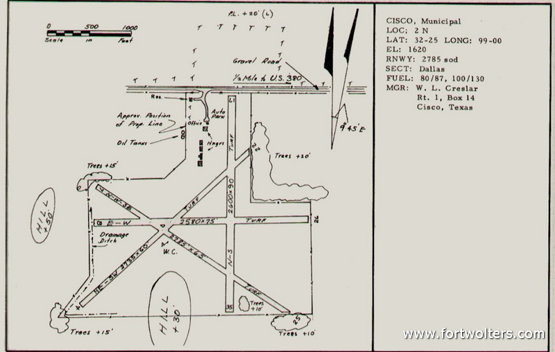
| Cisco Municipal Airport | 1620' |
NL002865 | ||
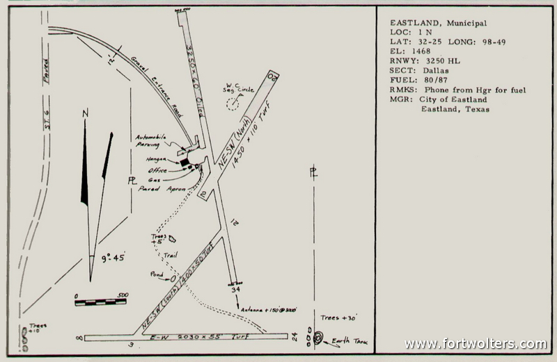
| Eastland Municipal Airport | 1468' |
NL178862 | ||
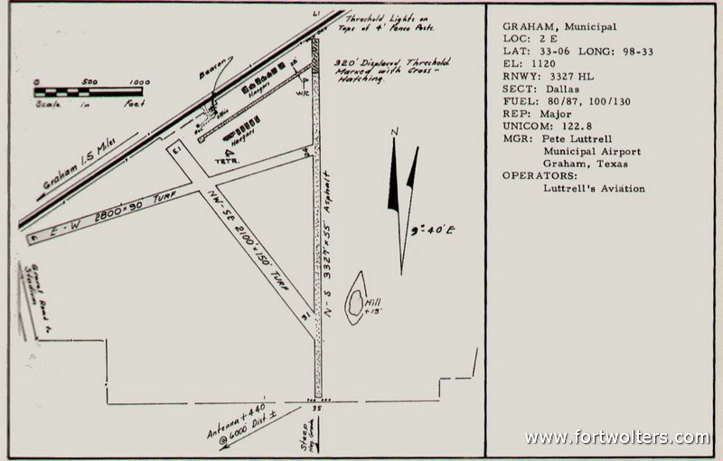
| Graham Municipal Airport | 1120' |
NM136634 | ||
| Gainesville Municipal Airport | 833' |
PL113899 | ||
| Jacksboro Airport | 1100' |
33°13'41"N 98°08'47"W | NM797770 | |
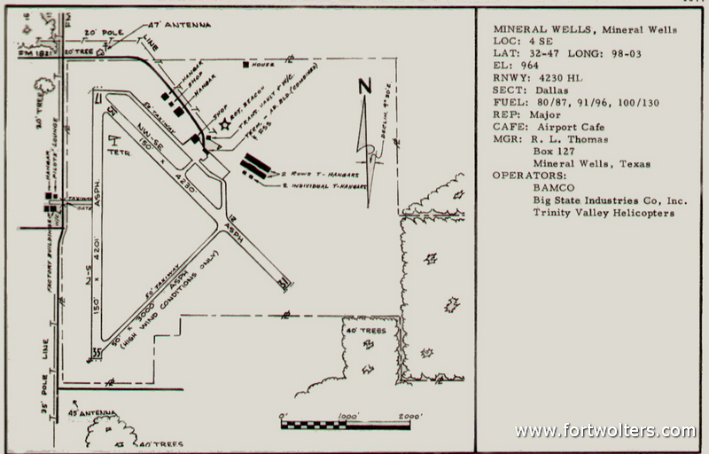
| Mineral Wells Airport | 964' |
NM880273 | ||
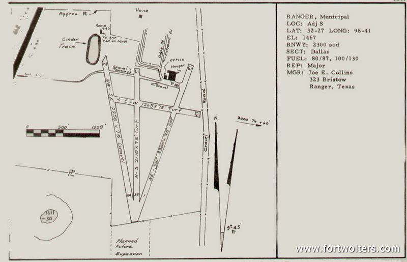
| Ranger Municipal Airport | 1467' |
NL300905 | ||
| Stephens County Airport (Breckenridge) | 1282' |
NM101199 | ||
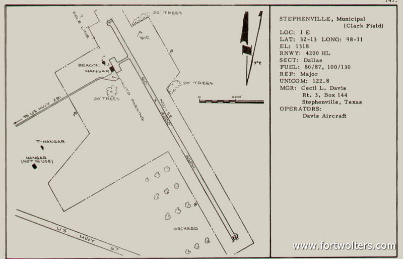
| Stephenville Municipal Airport | 1318' |
NL775645 | ||
| Weatherford Airport (Parker County) | 991' |
PM235239 | ||
All drawings of Civilian fields taken from 1963 Directory of Texas Airports. Published by The Texas Aeronautics Commission. |
||||
|
The locations that I mention on my website were taken from a map we used while flying in the 1960 - 1970s period from Fort Wolters. The map was referred to as the "Crash Rescue Map" and was published by the Army Map Service (which was I believe was part of the Corps of Engineers) at a scale of 1:100,000. Normally the tactical maps we used in Vietnam and the rest of the world were at a 1:25,000 scale and compiled from photogrammetric methods. In the example of the An Khe Stagefield (NM977350) the NM was the 100,000 meter square where the geographic point lay. The 97 was the vertical grid line (longitude) and the 35 was the horizontal grid line (latitude). To find coordinates we would always start reading the map from the lower left corner and then read to the right (longitude) and then upwards (latitude). For those that are interested, there are free converter programs available on the web that convert the coordinates from the those on the Crash Rescue Map to standard coordinates that you could use in your GPS. Or, if you click on the link to the Crash Rescue Map Gallery it will display a larger scale image of the the map and you could correlate these with Bing, Google or other maps. I highlighted the Heliports, Stagefields, etc. for easier location - most are on East -03; East - 05; West - 04; and West - 06. The Coordinates are the standard latitude/longitude method of finding geographic locations. Jesse Faris has kindly converted all of the Army Map Service coordinates of the Stagefields to their corresponding latitude/longitude coordinates, which I have hyperlinked directly to Google Maps. Thank you Jesse for your hard work!! |
||||
The data on the individual Stagefield pages are mainly taken from U.S. Army manuals, documents and photographs that I used or obtained while I was stationed at Fort Wolters. The Boyce Ditto Library in Mineral Wells kindly allowed me to fill in and use some of the Stagefield data and photographs that I was missing from my records. Palin Bree is the Library Manager at the Boyce Ditto and has been very kind in allowing myself and other researchers access to their collection of Fort Wolters archives. Thank you Palin so much for your generosity!! |
||||