
- Home
- Camp Wolters
- A Model Soldier
- Camera Trip Through Camp Wolters
- Camp Wolters Longhorn
- Camp Wolters Ephemera
- Camp Wolters Guide
- Camp Wolters IRTC
- Camp Wolters Postcards
- Camp Wolters Unit Photos
- Christmas Menu
- Present Site of Camp
- Southwestern Bell Booklet
- Camp Wolters Souvenir Book
- IRTC Doughboy
- Soldier - Billy S. West
- Soldier Artist
- Soldier's Letters
- Soldier's Photos
- Fort Wolters
- United States Primary Helicopter/School
- Flight Training
- ORWAC Class 68-24
- WORWAC Class 67-5
- Training Aircraft
- Stagefields and Heliports
- Southern Airways of Texas
- USAPHS Commandants
- Battery D, 4th Missile BN 562nd Arty
- 328th U.S. Army Band
- Det. 20, 16th Weather Squadron
- Guide and Directory
- Crash Rescue Map
- Dave Rittman Photos
- Fort Wolters Photo Gallery
- Fort Wolters Ephemera
- Wolters Air Force Base
- Fort Wolters Main Gate
- Around Mineral Wells
- Texas Forts Trail
- Vietnam
- Sitemap
- Links
- About the Site
- What's New
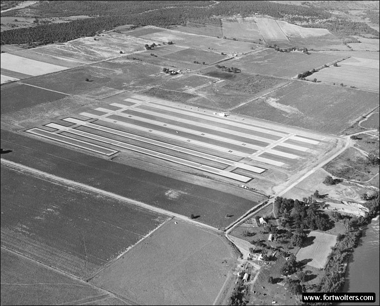
U.S. Army Photo - Private Collection |
|
|---|---|
Stagefield: RAWHIDE (Stagefield 5) Latitude/Longitude: 32°46'28"N98°10'33"W Army Map Service Coordinates: NM773260 Telephone Number: Fort Wolters Ext 3619 Elevation: 845 ft Traffic Pattern Altitude: 1400 ft Radio Call: Rawhide Frequencies: 149.90
GENERAL NOTES 6 Lanes : 1600' x 50' each Hovering Area: 900' x 75' Parking Area: OH-23 - 32; TH-55 - 42
Fixed Lighting: Lanes 3 & 4 - Runway Lights Lanes 1, 2, 5, & 6 - Approach Lights Electricity: Commercial Power
Windsocks: 3: 1 near tower, 1 SW corner, 1 NE corner tower
Wind T: Lighted, located mid-field
Permanent Control Tower: Air conditioned, light gun, wind velocity and direction indicator, flight training status lights.
Radios Available in Tower: 2 ARC - 60 radios (UHF) - 1 ARC - 524 (VHF)
All weather access road Distance from Fort Wolters: Air - 7.2 NM - Ground - 11.6 SM
Ready Room: 10tables with chairs, air conditioned, potable water, permanent latrine, commercial electricity, blackboard, area map.
Wind T: Lighted, located mid field
Restricted Areas: Town of Garner east of field, 1 house south of Garner, SE of field; 1 house 1/2 mile SW of field.
Remarks: Farm house east of field; Guest Ranch 4 km NNE of the field.
TRAFFIC PATTERN; a. Entry to east traffic will be made on base leg in order to avoid farm house east of field. b. When flying closed traffic in east traffic, downwind leg will be flown west of farm house of field. |
|
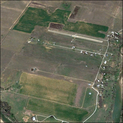 Present Day Aerial View