
- Home
- Camp Wolters
- A Model Soldier
- Camera Trip Through Camp Wolters
- Camp Wolters Longhorn
- Camp Wolters Ephemera
- Camp Wolters Guide
- Camp Wolters IRTC
- Camp Wolters Postcards
- Camp Wolters Unit Photos
- Christmas Menu
- Present Site of Camp
- Southwestern Bell Booklet
- Camp Wolters Souvenir Book
- IRTC Doughboy
- Soldier - Billy S. West
- Soldier Artist
- Soldier's Letters
- Soldier's Photos
- Fort Wolters
- United States Primary Helicopter/School
- Flight Training
- ORWAC Class 68-24
- WORWAC Class 67-5
- Training Aircraft
- Stagefields and Heliports
- Southern Airways of Texas
- USAPHS Commandants
- Battery D, 4th Missile BN 562nd Arty
- 328th U.S. Army Band
- Det. 20, 16th Weather Squadron
- Guide and Directory
- Crash Rescue Map
- Dave Rittman Photos
- Fort Wolters Photo Gallery
- Fort Wolters Ephemera
- Wolters Air Force Base
- Fort Wolters Main Gate
- Around Mineral Wells
- Texas Forts Trail
- Vietnam
- Sitemap
- Links
- About the Site
- What's New
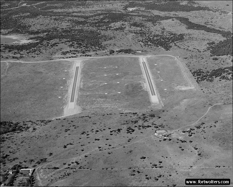
U.S. Army Photo - Private Collection |
|
|---|---|
Stagefield: VINH LONG Latitude/Longitude: 32°43'54"N 98°19'40"W Army Map Service Coordinates: NM629215 Telephone Number: None Field Elevation: 1220 ft Traffic Pattern Altitude: 1700 ft Radio Call: Vinh Long Frequencies: 245.7 - 141.30
GENERAL NOTES 2 Autorotation Lanes: 1600' x 50' 4 Approach Lanes: with 4 pads per lane 30' x 30' 1 Refueling
No fixed lighting Electricity: ONAN Portable Generator, 10KW
Windsocks: 2; 1 each in NE and SW corner
Permanent Control Tower: Air conditioned, light gun
Radios Available in Tower: 2 ARC - 60 (UHF), 1 ARC - 524 (VHF)
All weather access road
Ready Room: Not air conditioned, no water available at site, temporary latrine, 6 tables with chairs
Distance from Fort Wolters: Air 15.9 NM; Ground 23.0 SM
Restricted Areas: None
Remarks: a. Use caution when performing autorotations on Lane 5 due to an uneven elevation.
b. Use caution when hovering between lanes due to large rocks, tall weeds and uneven terrain.
|
|
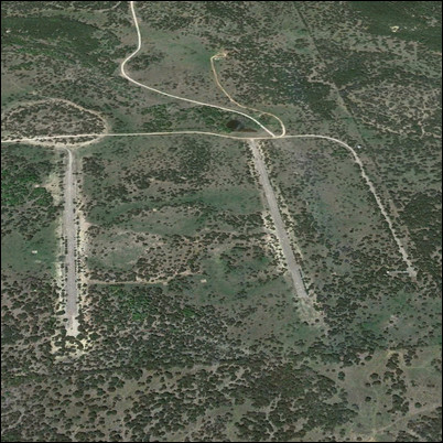 Present Day Aerial View